Messages posted by : admin
J2Ski Snow Report - March 6th 2025
Started by Admin in Snow Forecasts and Snow Reports, discussing Alpe d'Huez and Serre Chevalie... |
|
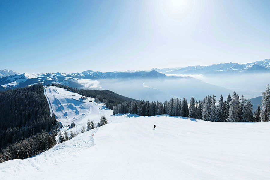
Zell am See, Austria (and most of the Alps) got a lot of sunshine, and had quiet slopes, this week... Sunny in the Alps, snow in the Rockies and (again) in Japan. Snow in the forecast for some parts of the Alps, Dolomites and Pyrenees next week. The Snow Headlines - March 6th - Sunshine dominated in the Alps. - The deepest snow in Japan (and the world) reaches 7.5 metres. - Heavy snowfall is forecast for the Pyrenees. - Up to two-feet of snowfall in The Rockies. 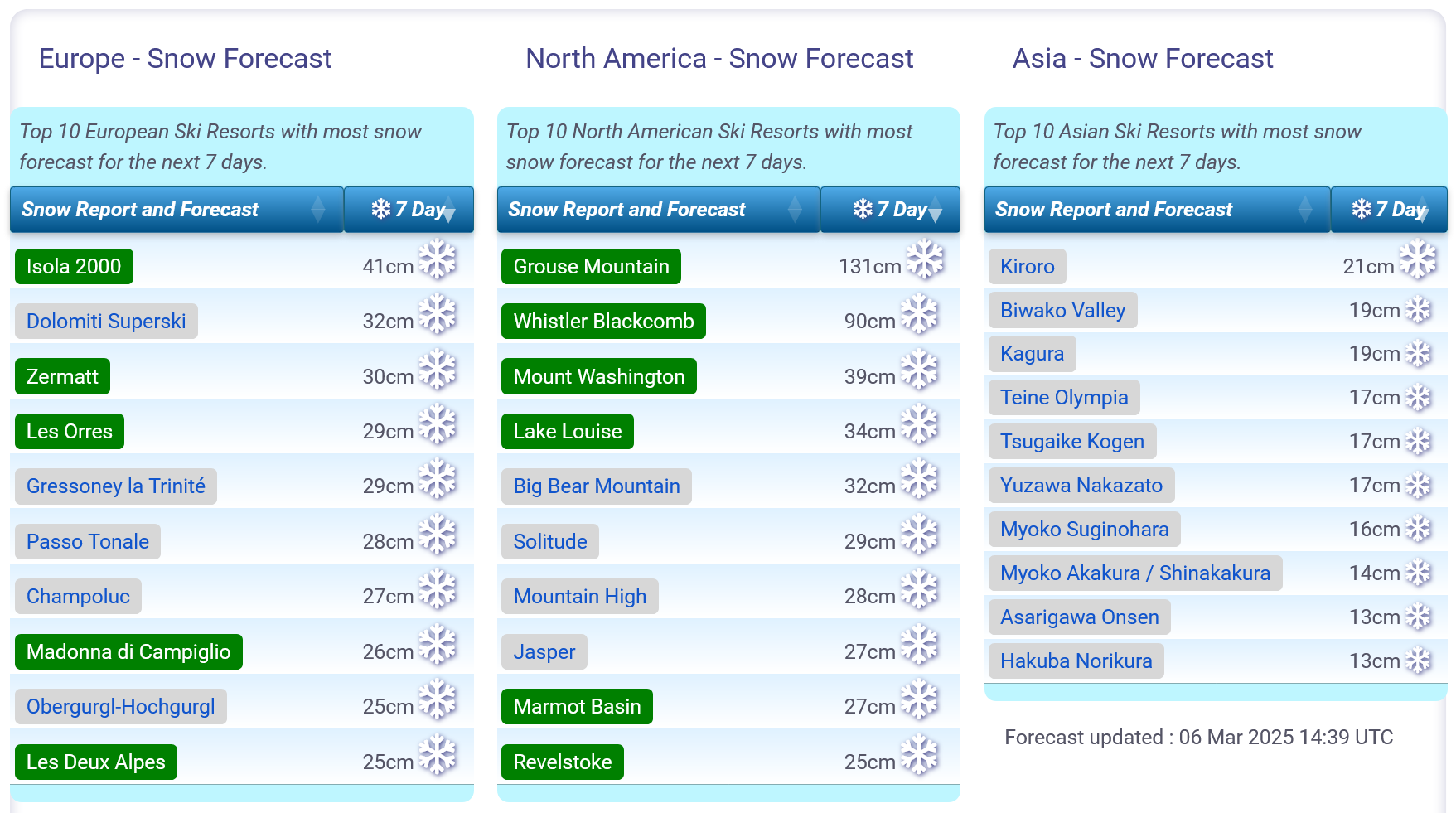
Snow forecasts worldwide.
World Overview Spring has sprung in the Alps, even if we are still only in meteorological springtime; the traditional Astronomical seasonal measure still has a fortnight of winter to go. Despite widespread spring conditions, most resorts have all their terrain open (more or less) so it's great spring skiing in the sunshine from mid-morning to early afternoon on the groomed runs and longer at higher altitudes. The avalanche danger has also dropped. Elsewhere in Europe, the Pyrenees is the region that's currently cooler with regular snowfalls. Scandinavia has had some snow too but it's had rain in some places too as temperatures have warmed. In North America, the rain issue has impacted the East Coast as well and it has also been a drier week overall - although with snow in the Rockies. Europe Austria It's been a week of near-constant sunshine in the Austrian Alps with warm, sunny weather and afternoon highs getting above +10C in lower valleys. It's classic springtime freeze-thaw weather, with overnight lows on higher slopes getting below -10C still. Most Austrian ski areas continue to have almost all of their slopes open, despite temperatures causing the valley snowlines to climb ever higher. The Arlberg region around St Anton and Lech has the most terrain open in the country with 285km of slopes, more than 95% of its full area. France It's been a sunny week across the French Alps too, bringing beautiful conditions on the groomed runs after last week's snowfalls. It is March though so no surprise that temperatures are now reaching +10C in the afternoons in valleys, impacting snow quality. All of the big French ski regions continue to report their slopes as 80-90% open for now. There's no huge change in the forecast really other than a front expected to make its way north from the Pyrenees on Sunday which could bring 10-20cm accumulations, perhaps more, before the sunshine returns, to more southerly ski areas like Alpe d'Huez and Serre Chevalier. Further north though may not see anything or just a few centimetres. Italy It's been a largely sunny week in Italy as well after some light snow showers at the weekend, mostly focussed around the Trentino region where ski areas posted accumulations of up to 40cm over 72 hours with typically 5-15cm per 24 hours. Other parts of the country remained dry and whilst the clear skies delivered low overnight temperatures, daytime highs at low elevations reached +10C impacting the quality of the generally thin cover on lower slopes. Despite that most Italian ski areas remain almost fully open, the largest in the west, the Milky Way/Via Lattea with about 80% of its slopes and Dolomiti Superski in the East at 90%. Aosta valley ski areas may benefit from the snow moving into the area early next week, which should at least provide a freshen-up, if not some decent powder. Switzerland Swiss centres have enjoyed the sunny weather too, with temperatures climbing into double figures above freezing in the afternoons in valleys and the snowline rising up the valley sides. The freezing point has also been getting as high as 2500m altitudes after lunch but has still been dropping down to resort level overnight, giving the familiar springtime freeze-thaw conditions. As elsewhere most Swiss ski areas reported 80-100% of their slopes open with several resorts including Saas Fee reporting 2.5m+ bases up high. The sunshine is expected to continue for the next few days with a front moving in late in the weekend and early next week due to bring a change to conditions then, with moderate snowfall. Scandinavia More unsettled weather in Scandinavia than further south, especially in the region's west which has been one of the few parts of Europe reporting snowfall this week. Unfortunately, it's also been reporting rain, sleet and gales at times so it's a case of some good days, some not so good. The rain and sleet reported at resorts like Hemsedal and Voss reflect the fact that we've gone from constantly sub-zero temperatures in January and February to currently a -8 to +8C range in the southern part of the region. Overall though everything is looking pretty positive in terms of open terrain – at the maximum of the season to date for most areas. Pyrenees The Pyrenees have turned out to be the corner of Europe that's seen the most snowfall this week. It's been mostly low-level, a few centimetres here and there, particularly on the French side with St Lary posting 6cm on Monday, the most reported anywhere in Europe that day! The snowfall has intensified a little in the past 24 hours and is expected to continue through the weekend as much of the rest of the continent remains dry. Temperatures are cooler here too in the -10C to +3C range so it seems that for powder hunters, this weekend the Pyrenees are the place to be. Scotland Scottish centres have seen some snowfall but also rain and sleet showers at times with temperatures climbing above +10C at base levels. So there's little open beyond the small areas of all-weather snowmachine maintained slopes at Glencoe, Glenshee, Cairngorm and The Lecht. That said some natural snowpacks survive on high slopes and ski tourers at Glencoe have been able to use the access Chair to reach some of it, whilst at Cairngorm the re-opened funicular takes skiers and boarders to an in-bounds area around the Ptarmigan T Bar. Nevis Range is yet to open this winter. Eastern Europe It's been a dry and sunny week right across the sweep of Eastern Europe from the far north in Poland and Slovakia to the south in Bulgaria. The southerly Balkans have been posting lower temperatures than the Alps further north at times, although here too it's now been hitting +10C and higher at lower elevations. Fortunately, reported spring base depths for resorts like Bansko and Borovets remain the best they've been for several years and both report almost all their runs open. There's currently no real change in the forecast, with warm, sunny weather through the weekend, just a little cloud bubbling up in the north early next week. North America Canada It's been a largely dry week across Canada with just some light snow showers in the West adding 5-10cm of fresh cover, although, in fact, bases have dipped about 10% as with slightly warmer weather and the snowpack settling, things have dropped slightly. Across the west of the country, conditions remain excellent with great snow cover and everything open, temperatures up to -15 to +5C from their previously constantly sub-zero state. It's a slightly more mixed picture in the East. Again conditions are good on the whole with everywhere open, but we have seen a return of warm weather spells bringing sleet and rain as well as the snow showers. USA A quieter week across the US with some snowfall, but not a lot, reported in the Rockies and on the West Coast, particularly for Utah and California. The past 48 hours have seen up to 30cm of snowfall reported in Colorado and Utah's Snowbird say they've had 58cm (2 feet) since Monday. As with Europe, temperatures have been climbing and sleet and rain has visited the Midwest and Northeast after the frigid winter months, leading some centres there to close temporarily until the rain has passed and the slopes regroomed. Mammoth in California continues to post North America's deepest base at 4.5 metres after big snowfalls there last month. |
|
J2Ski's Where to Ski in March 2025
Started by Admin in Snow Forecasts and Snow Reports, discussing Avoriaz and Chamonix |
|
|
March starts with Japan leading the snowfall tables, North America about average and Europe quite variable according to location. Snow is forecast for Scandinavia, but a mild week ahead for the Alps.
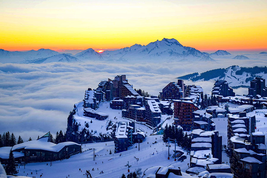
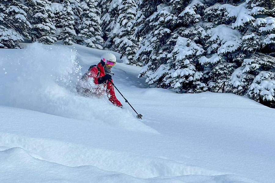
The sun setting at Avoriaz, France, this evening. Where to Ski in March 2025 March marks the start of springtime and the start of the end of the northern hemisphere's ski season. With long daylight hours and rising temperatures, the quality of the snow changes as does the atmosphere, becoming more relaxed and less intense. The start of the month usually sees the high point of snow depths, before the spring thaw begins. For 2025 it's a mixed bag. Japan is the stand-out ski nation for snowfall to date, the month starting with the first areas having passed the 7m base mark, the deepest anywhere for several years. North America is running at about average, and Europe's numbers are fairly unimpressive. In Europe, base depths have grown in March and April in recent years due to late-season snowfall so it remains to be seen if that happens again in 2025. March starts with fairly decent snow depths and everywhere fully open, or almost so. There are a few exceptions, notably Scotland, but overall it's a positive picture. Europe Austria Austria tends to see more of its centres close in late March or the very start of April than the other three major ski countries in the Alps. This winter has been marked by a lack of heavy snowfall with many ski areas yet to really see one-metre base depths reached on higher slopes, while valley runs have been maintained by snowmaking. Despite that, the month starts with the majority of runs in the country open. The Arlberg (St Anton, Lech etc) is reporting the most at 280km (175 miles) about 98% of its full area and Saalbach Hinterglemm and Ischgl Samnaun also both have more than 200km of slopes open. France Although French Alps snow depths aren't the greatest ever, they are the deepest in Europe as we start March, with several areas including Chamonix and Flaine posting 3m+ (10 feet plus). On top of this most of the country's larger destination ski area areas, including the big players like the 3 Valleys, Grand Massif, Portes du Soliel and Paradiski report their slopes close to 100% open. Most French areas stay open through March and this is also when a spate of music festivals including Rock The Pistes and Tomorrowland Winter are staged on slopes across the country. Italy Italy hasn't had much snowfall this season, but most of the country's ski centres are reporting their slopes fully open for March, albeit with thin cover, typically less than half a metre, much of it machine-made snow, across their slopes. Dolomiti Superski is at the forefront with almost all of their 1,200km of runs available. The deepest cover is at La Thuile on the French border where it's up at 2.5m. Switzerland As with the rest of the Alps, conditions are pretty good in Switzerland as we start March. Here too, most of the country's well-known destinations report pretty well all of their slopes open. The region that had had the least snowfall this season, down in the southeast around St Moritz and Arosa, did have one of the better accumulations in the latter half of February, bolstering cover. Base depths are below average, most noticeably at lower elevations where it's the white slopes on green valley backgrounds. Temperatures reached +10C at 1,000m in the final week of February so the snowline is rising. Scandinavia Snowfall in Scandinavia this season so far is running below average, but not that far below average and February, along with some very low temperatures, saw more and more terrain opening. As we start March most of the region's ski areas remain 60-80% open, still not every slope yet. March is usually one of the best months for skiing in Finland, Sweden and Norway. As the weather becomes decidedly more springlike with often slushy snow in the afternoons in the Alps, it is typically colder with snow conditions better up in Scandinavia. In addition, there are increasingly long daylight hours at these northerly latitudes. Scotland It's been a pretty lousy winter so far in the Scottish Highlands with very low snowfall and a familiar pattern of spells of very mild, wet and windy weather repeatedly thwarting any snowpack build-up. Four centres, Glencoe, Cairngorm, The Lecht and Glenshee have all-weather snowmaking machines that can create small areas of snow to offer at least some skiing, and during the most positive spells, all have managed to open limited natural terrain. Spring does typically bring heavier snow so we have to hope for a late blast of winter. Nevis Range, which doesn't have an all-weather snowmaking machine, is yet to open this winter. Pyrenees The Pyrenees haven't had the best of seasons; it started late, about a third of the way into December, after a big snowfall saved a largely snowless autumn. Not much changed through December and January but last month did see snowfall for much of it, in varying amounts. Although few areas are 100% open, conditions are currently the best they've been all winter with the biggest areas like Spain's Baqueira Beret and Andorra's Grandvalira reaching 75-85% open. Eastern Europe It looks pretty good across Eastern European ski slopes from north to south as we start March. Bulgaria and the wider Balkans ski region have been posting healthy snow depths (approaching 2m up top) since the start of the year – better than a lot of areas further north. Resorts in the Tatras and Carpathians up in Czechia and Slovakia haven't had so much snowfall and are mostly down below the metre mark - but do start March reporting all runs open for them too. North America Canada Conditions are about as good as they get as we start March across Canada. A month ago, things were already good in the west, with everything open and above-average snow cover – that's still the case now after a very cold February ended with some significant fresh snowfalls. On the East though there was inadequate cover after a poor first half to the season left areas struggling to open runs still. A cold and snowy February for Quebec, Ontario and the wider region has fixed that leaving good conditions here now. USA Conditions are fairly good across the US as we start March with most areas across the country fully open. Some very cold temperatures and very heavy snowfall in February have helped a lot. The country's national weather forecasting agency has put out a March forecast predicting below-average temperatures and above-average snowfalls this month in the Pacific Northwest region. It's less promising for the Rockies though, at least the southern half, where temperatures are expected to be warmer than average and precipitation lower – that includes Colorado and Utah. Most of the rest of the country looks around 'average' for this point in the season. Asia Japan has been having an incredible snowfall season and resorts there have been posting base depths topping 7 metres in the final week of February, the deepest in the world not just this season but for several seasons. March is usually a month of fast change in Japan when the daily dumps suddenly end and the snowpack, however deep, becomes more granular and less the light, deep, floaty stuff it's famous for. This spring it will still be deep, just perhaps not powdery for very much longer. Most major ski areas will be open until the country's annual 'Golden Week' celebrations in early May. |
|
J2Ski Snow Report - February 27th 2025
Started by Admin in Snow Forecasts and Snow Reports, discussing La Plagne and Les Arcs |
|
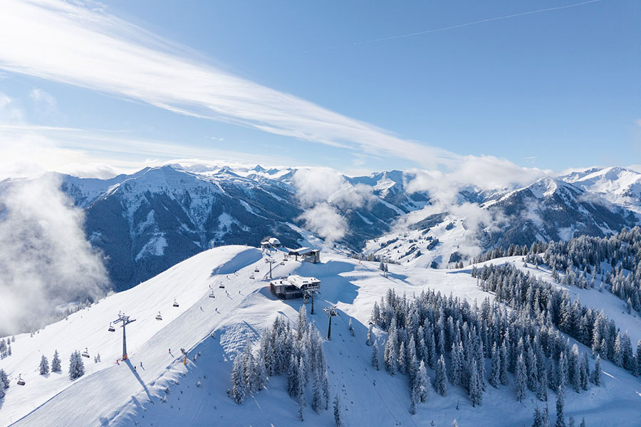
Saalbach Hinterglemm Leogang Fieberbrunn, Austria, this week... Seven metre snow depths in Japan, sunshine (and fresh snow in places) for Europe and a snowy week in NW North America. The Snow Headlines - February 27th - First ski area in the world to reach a 7-metre base depth this winter is in Japan. - Snowiest week in February for North America's Pacific Northwest corner. - Deepest snow depths in the US up 50% in past few weeks to 4.5m (15 feet). - New snow freshens things up nicely for some European slopes, sunshine elsewhere. - Mild temperatures wipes out thin snow cover in Scotland. 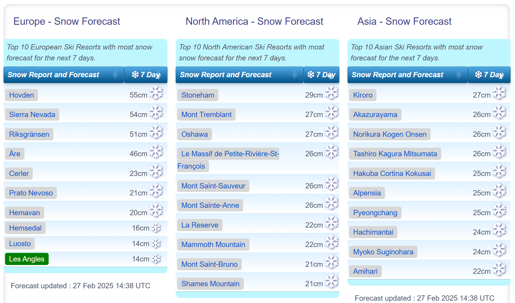
Snow forecasts worldwide.
World Overview Conditions have turned quite changeable across Europe this week as we move into springtime (by the meteorological measure of the seasons). Dry weather last week was punctuated by weak fronts moving in, bringing light to moderate snowfall, particularly in the Pyrenees and southern and western Alps. Temperatures have inevitably been creeping up, and it is now rather warm in the afternoon in valleys, pushing the snowline up and meaning precipitation is falling as rain at times, at least at lower levels. North America has seen the bigger snowfalls, again, although not so big as in recent weeks. The Rockies got snow up to the weekend but it's been warmer and drier since. It's the Pacific Northwest corner (Oregon, Washington State, Alberta and BC) that has seen the best of it, picking up more than half a metre of snowfall in the best cases delivering powder conditions. That continues to be the case across the Pacific too, with more Japanese ski areas passing the six-metre base depth mark after more heavy snowfall and the first there this season (and for several seasons) reaching 7 metres. Europe Austria Austria has had a week of mixed weather, with spells of sunshine, low clouds, and light snowfall, and some resorts seeing slightly more substantial 5-10cm accumulations in recent days. It's been fairly mild too, considering it's still February, with valley highs reaching +10C in afternoons, pushing the snowline further up valley sides, although pistes are being maintained down to base levels. Most Austrian ski areas remain fully open with the Arlberg region including Lech and St Anton reporting the largest area open in the country - almost 300km. France French ski areas had a slightly snowy start to the week as fronts moved up from the Mediterranean bringing light to moderate snowfall, most notably above about 2,000m. Warmer weather at lower altitudes meant some saw rainfall at times. High altitude areas like Les Arcs and La Plagne posted 30-40cm accumulations in total over the first half of this week. Skies are starting to clear now though with sunnier weather and slightly cooler temperatures expected for the final days of February and the start of March. Italy A bit of a holding pattern in Italy with little change on conditions a week ago. It has been warmer at resort bases, getting as high as +12C in the afternoon down in valleys but the past few days have brought lower temperatures, low cloud and some light snowfall. Slopes up above 2,000m have seen the most (10-20cm) accumulations, but for most areas it has been more like 5-10cm. Although warmer during the day, overnight lows have enabled snowmaking systems to keep operating. The coming week looks like its back to sunshine and increasingly warm temperatures however. Switzerland Swiss centres have enjoyed snowfall, heaviest in the west, over the past few days. Accumulations of up to 30cm were reported for ski areas including Crans Montana, Leysin and Saas Fee. The snow arrived after a rather murky start to the week with warm temperatures leading to hill fog and a bit of a thaw, especially at lower levels. Most Swiss ski areas remain fully open with Verbier and the 4 Valleys and the Zermatt-Cervinia region posting the most terrain available. Skies have started to clear now and it looks like a sunny weekend ahead and continuing so next week, with temperatures rising after a cold few days. Scandinavia A better week, on the whole, across Scandinavia with some light-moderate snowfalls that actually got heavier than normal for the region (up to 35cm reported in 24 hours) on Monday. However, temperatures have been getting above freezing and there have been reports of rain rather than snow at times on some lower slopes. Norway's Voss was one of the ski areas doing particularly well for snow, reporting more than 50cm of snowfall this week, although it was also one of those reporting rain at lower levels on occasion. It's looking a little drier for most areas through the weekend. Pyrenees After last week's largely dry, sunny weather with warmer temperatures, it's been a much better period of colder temperatures and light to moderate snowfalls since the weekend in the Pyrenees. There have not been any huge snowfalls but enough to give slopes a nice refresh and stop the depth stats from their freefall. Andorra's Grandvalira (Pas de la Casa, Grau Roig, Soldeu, El Tarter et al) continues to post the most terrain open, about 185km or 85% of its slopes, the most it's had open all season. Scotland Scotland is enjoying or enduring (depending on how you look at it), its familiar pattern of snowfalls followed by warm spells preventing base depths from building on the mountains like they used to. There have been some long, sunny, cold spells but they've tended to happen when there's little snow lying, not after the bigger falls. Four centres (Glencoe, Glenshee, Cairngorm and The Lecht) have some terrain open thanks to all-weather snowmaking machines. Nevis Range doesn't have one and is yet to open this season. It's looking fairly promising for hill snow, Glencoe reported 15cm on Wednesday, but the forecast is looking warmer and drier over the coming days. Eastern Europe A fairly dry week in Eastern Europe too, although temperatures have actually been a few degrees cooler in the Balkans, as well as further north in countries like Czechia, Poland and Slovakia. Here too, most ski areas are fully open. Resorts in Bulgaria are posting some of the best snow depth stats in Europe, touching 2 metres at Bansko and Borovets. The week ahead looks similar, just slightly warmer, with plenty of sunshine and just occasional light snowfall. North America Canada A big week in western Canada with some of the best snowfalls this month in what had been a very cold but relatively dry February. Ski areas here are reporting up to 50cm of snowfall since Saturday. Big White, Lake Louise and Whistler are among the resorts to report 30cm of snowfall in the last 72 hours and powder conditions. It remains good over on the east coast too, with temperatures still dipping down to the -20s there and all terrain open. USA Mixed conditions across the US this week with the heaviest snowfall reported in the country's Pacific Northwest corner in states like Oregon and Washington. Unfortunately, although higher slopes got more than a foot of snow, lower runs saw rain at times and there have also been very strong winds in the region, so much so that several ski areas in Oregon were closed on Tuesday-Wednesday. There's been some lighter snowfall in the Rockies but also warmer weather - and bases have actually dropped a little here whilst rising in the north of the region. Overall conditions are pretty good across the country with most resorts still fully open. |
|
J2Ski Snow Report - February 20th 2025
Started by Admin in Snow Forecasts and Snow Reports, discussing Chamonix and St. Anton am Arlb... |
|
Keystone, Colorado, got the goods this week... Some big snowfalls in the US this week, Colorado and The Rockies in general looking good. Mild and sunny in the Alps, with cold and snow expected next week for parts. The Snow Headlines - February 20th - Up to 140cm (4.5 feet) of snowfall in 48 hours in California. - Sweden's Riksgransen opening for its 2025 season. - Ski areas in the Rockies enjoy snowiest week of the season, up to a metre reported. - Biggest snowfall for a fortnight in the Alps, up to 30cm in 24 hours. 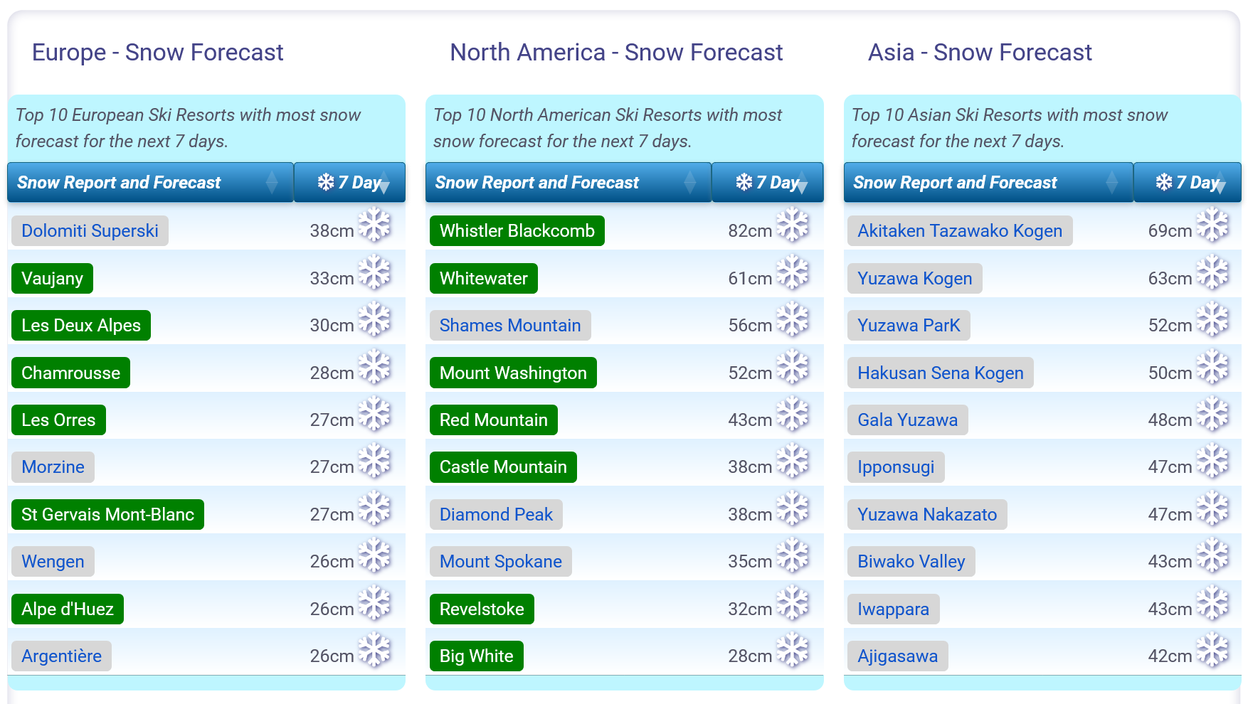
Snow forecasts worldwide.
World Overview After the snow showers that ended last week, it's been a largely sunny picture across much of Europe since the weekend. Temperatures have also been on the rise, most noticeable at lower elevations with afternoon highs reaching +10C in valleys, giving an early spring-like feel, although a return to cold looks likely next week. It's been similar across the Alps, Dolomites, Pyrenees, Eastern Europe and even up in Scandinavia and it looks like it will continue that way through the weekend for most areas. Most slopes are open across the continent. In North America, it's probably been the best week of the season, so far; ski regions across the continent have been getting substantial fresh snowfalls, leaving great conditions and everything open. Japan continues to post the world's deepest snow depths this season so far, at up to 6 metres. Europe Austria It was a sunny week in Austria after unsettled weather at the end of last week. With temperatures reaching +11C in valleys in the afternoons, the snowline is creeping up valley sides, and lower slopes are white lines in the lowest areas. Despite these early spring challenges, most areas are fully open with resorts like Saalbach Hinterglemm, St Anton / Lech (The Arlberg), Ischgl-Samnaun and the Skiwelt (Soll, Westendorf, Ellmau et al) reporting their slopes 95-100% open. France Sunny skies across French ski slopes since the snowfalls at the end of last week brought accumulations of up to 30cm for ski areas including Chamonix and Flaine; which are now posting Europe's deepest snowpacks at about 3.3 metres (11 feet). It's been busy on French slopes with the half-term holidays but most areas continue to report all of their slopes open, enabling the crowds to disperse across the mountains each morning. The 3 Valleys and Portes du Soliel both have more than 95% of their 600km or so of slopes available. The forecast is currently for it to stay dry through the weekend, with plenty of sunshine but a little more cloud than there has been. A return to cold looks likely around the middle of next week, although that's quite uncertain as we write this. Italy Sunshine has also dominated the weather in Italy this week after the unsettled conditions in the first half of the month. Temperatures have also been climbing with daytime highs getting close to +10C in the afternoons in valleys. Overnight lows continue to drop well below freezing under the clear skies though, allowing resorts to make more snow as required. As it is, on the groomers at least, conditions remain excellent with most slopes open across the country. The vast Dolomiti Superski with its 1,200km of slopes reports there are more than 90% open, with several sectors, including Val Gardena, at 100%. Switzerland As with the rest of Europe, it's been a mostly sunny week on Swiss slopes. Here too daytime temperatures have been climbing with valley highs topping +10-C and the freezing point climbing up above 2,000m altitudes. Most of the large ski areas including Verbier's 4 Valleys and the Zermatt-Cervinias cross-border pass are at 90% or more open, the most of the season. And here too it is expected to stay dry through the weekend, with a mix of sunshine and cloud, temperatures dropping a little but staying rather springlike. Scandinavia Scandinavian ski stats have changed little on seven days ago after plenty of sunshine and just the odd light snow shower across the region. The main difference, not published in many resort snow reports, has been fast-increasing daylight hours at northerly latitudes, with the Arctic Circle ski areas of Bjorkliden (last weekend) and Riksgransen (this weekend) opening for their 2025 seasons as a result. The amount of open terrain has grown a little this week at most Scandi ski areas with Sweden's Are resort posting the most, around 75km/80% of its slopes. The forecast is a little more unsettled with slightly more snow falling over the coming week. Pyrenees After a fortnight of colder, snowier weather than they had in the first few months of the season, it has been back to sunny skies in the Pyrenees with temperatures climbing up to +12C at resort level, setting back some of the snow gains of the last few weeks. Ski areas report the most terrain they've had open all season thanks to that snowfall in the first half of February with the biggest, Andorra's Grandvalira (Soldeu, Pass de la Casa etc) at 90% open with nearly 200km of slopes available. More unsettled weather is expected for the rest of this week with temperatures set to drop; a front should bring 10-20cm accumulations by Monday. Scotland Familiar frustrations for Scottish ski areas and skiers with a fortnight of very cold, but dry weather when little was open due to the previous thaw, ending with a decent snowfall that could have been the start of base re-building, but temperatures are set to hit +12C over the weekend making that seem unlikely. Currently, Glencoe and Glenshee have had a little natural terrain on top of the small all-weather snowmaking machine-maintained areas but it remains to be seen how much of that will survive the coming warm spell. Cairngorm and The Lecht also have small areas open, Nevis Range is yet to open this season. Eastern Europe Bulgaria, which had had dry and sunny but generally cold weather for much of the past month finally saw some snowfall earlier this week, giving a good slope refresh for ski areas like Borovets, Bansko and Pamporovo. They have all slopes open and it's a similar story further north with the big names in Cezchiua, Poland and Slovakia like Jasna also fully open, although it's been dry and sunny here. North America Canada Remaining very cold with some light snowfall in Western Canada; conditions are generally excellent here with deep cover and resorts reporting every slope open. There's been a bit of a holding pattern with those conditions for 3 or 4 weeks now but there are finally signs of change with more significant snowfalls, potentially 40-80cm of snow, expected through the weekend. On the East Coast, the snow has kept falling in Quebec and conditions are the best they've been all season. It's looking a little drier there over the coming week, temperatures remaining sub-zero but not quite as cold as they've been – down to -20C instead of -30C! USA Some big snowfalls across the US this week with all ski regions of the country seeing some significant snowfalls. California got the most as a 48-hour storm last week ended up dumping up to 4.5 feet (135cm) by Saturday morning. Mount Rose (Lake Tahoe) posted the most, but almost everywhere got at least two feet. Inland, The Rockies also saw some of their biggest snowfalls of the season, Utah's Deer Valley and Steamboat in Colorado among areas adding half a metre of snowfall to their base depths. Even the country's East Coast scored too, with more snow for New England. The bigger accumulations took some digging out and Californian centres delayed opening to do so, but overall conditions are excellent across the country with lots of fresh snow and everything open. |
|
J2Ski Snow Report - February 13th 2025
Started by Admin in Snow Forecasts and Snow Reports, discussing Jasná - Chopok and Livigno |
|
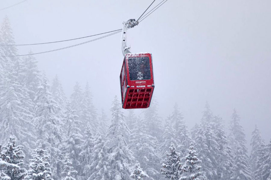
Snow today in many French ski areas, including Megeve... It's been snowing today in the Alps, although there is milder weather to follow. More heavy snowfalls in Japan, not so much in North America - but it's cold there! The Snow Headlines - February 13th - More huge snowfalls take Japan's base depths past 6m/20 feet mark. - Sunny weather in Scandinavia, which is posting the most terrain open this season so far. - Most large ski areas in the Alps report nearly all slopes open for half-term holiday crowds. - The Pyrenees enjoy some of the best conditions of season, with 30cm accumulations. - Frigid temperatures continue across North America and there's been some snowfalls too. 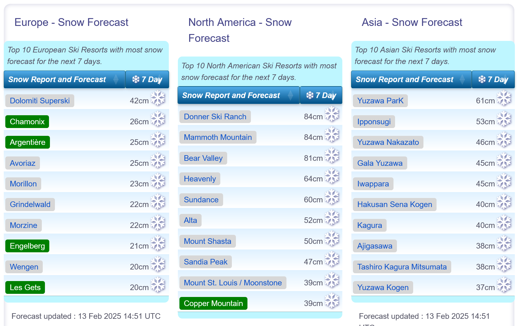
Snow forecasts worldwide.
World Overview The dry weather that has been dominating the weather in the Alps for the past fortnight has begun to break this week with multiple fronts bringing clouds and some mostly light snowfall across the region. Overall, base depths have been dropping as thawing and settling snowpack exceeds the gains. That's not a huge issue though as most resorts remain fully open. The snow depth numbers and open terrain stats have been on the up in the Pyrenees which has had a second successive week of snowy weather. Across in North America, it's been another cold week with moderate snowfalls - with heavier ones in the forecast again for the US West Coast. Japan is topping snow depth and snowfall tables with several centres there now reporting that the snow is lying over 6 metres/20 feet deep, the deepest snow anywhere in the world for several seasons and about double the deepest snow currently reported anywhere else. Europe Austria Austrian ski areas are seeing a little light snowfall after nearly a fortnight of dry weather. On the groomed runs at least conditions remain good across the country with most resorts fully open, even where snow cover in valleys has melted leaving the familiar white ribbons of maintained pistes descending from above. It's looking like a snowy end to the week, then back to sunshine for the weekend, and a fresh front bringing more snowfall early next week. France The mostly dry weather in France continues after the sunny week last week, although a number of ski areas have had a useful refresh in the last 24 hours. Southerly ski areas have fared well for fresh falls, with 20-30cm reported by some in the southern French Alps to start the week. It's been heavier in the Pyrenees. French ski areas continue to post the deepest bases in Europe and conditions are excellent for the busy February half-term holiday period. The main access road to the Tarentaise Valley (the N90) has been cleared of fallen rocks and is reported to be working well again (albeit with the usual heavy traffic for the half-term weekends). Almost all slopes are open across the country's larger destination resorts. After the current snowfall, the weekend currently looks set to be back to sunshine for most areas. Italy Italy saw some of the best snowfalls in Europe to start the week and a weather system from the south brought up to a foot of snowfall to the Aosta Valley, Lombardy and Trentino among other areas. So unusually for this winter, Italian ski centres started the week with more powder than those in the other three big-name ski nations of the Alps! Madonna di Campiglio was one of the bigger winners, posting 30cm of fresh snowfall. There was also 20cm in the Aosta Valley and some good accumulations for Livigno, Sestriere and others. Switzerland The weather has become more changeable on Swiss slopes this week with light to moderate snowfalls reported, initially heaviest in the south and east. St Moritz and the Engadin posted a 22cm accumulation on Sunday/Monday with the Aletsch Arena reporting a foot (30cm) of snowfall in the same period. For most areas though it was more in the 5-10cm range with cloudier skies than we've seen in recent weeks. A period of heavier snowfall is now moving in across the country. Scandinavia It's been a drier week with plenty of sunshine in Scandinavia. Ski areas here have been opening additional terrain and are now posting the most they've had open all season, in part thanks to rapidly increasing daylight hours following the dark December-January period. The deepest snow is on Norway's West Coast where Myrkdalen ski area reports fresh powder and a snow depth approaching 2 metres. Sweden's Are to the east has the most terrain open in the region, about 75km of slopes. It's looking a little snowier for the week ahead with temperatures continuing to be well below freezing. Pyrenees It's been a second good week in the Pyrenees, the region posting some of the best snowfall accumulations in Europe of the past week. St Lary in France and Formigal in Spain both posted 24-hour 30cm snow totals to start the week. That comes after snowfall the previous week too after a largely dry first few months of the season, so we're definitely seeing the best period of the season to date. The snowfall is thanks to weather systems moving up from the Med which didn't really reach much further north. Most of the region's ski areas now have the most terrain they've had open all season, typically 70-90% of their runs. Scotland Scottish ski areas are still suffering from a shortage of snow following a brief but significant thaw at the start of last week. Otherwise, it's really been a cold month, but as is often the case also a fairly dry one, with very little natural snow build-up. Glencoe has had the best of it in recent weeks, keeping half a dozen or so natural runs open, with Glenshee doing the same on a more limited basis. Otherwise what's open has been largely restricted to small areas of snow maintained with all-weather snowmaking machines. The Lecht has added terrain park features. With February half term here centres are warning of limited ticket availability due to the limited terrain. Nevis Range sadly looks set to remain closed and is yet to open this winter. Eastern Europe Dry weather has continued to dominate Eastern Europe with plenty of sunshine for the south of the region, more cloud and hill fog between clear spells further north. Bulgaria has also posted some of the coldest temperatures in Europe over the last week, down as far as -15C and rarely getting up above freezing in the daytime, whilst further north in countries like Czechia and Slovakia it has been more in the -5 to +5C range. The low temperatures mean there's been little change to snow depths, and have allowed snowmaking to replenish cover lost. Most ski areas in the region, including Bansko and Jasna, remain close to fully open. North America Canada It's been a fairly quiet week for snowfall in Canada, with, if anything, more falling in eastern provinces than western, as happens every now and then. Low temperatures, down to the -20s (C), continue to be a factor on the slopes. Most ski areas are reporting good conditions overall, with the low temperatures helping to keep the snow in good shape. Virtually every ski slope in the country is open with good depths in the west and the best conditions of the season to date in the East. USA The US has had a pretty good week with some good snowfalls reported in the Rockies, on the West Coast and in the Northeast. It appears it's set to get even better over the next few days too with major storms approaching on both the Atlantic and Pacific Coasts. On top of this, it has stayed very cold, which has helped preserve the snow cover and keep most centres fully open. Standouts of the past week include Colorado, which has had a rather dry winter though everywhere is just about fully open, seeing some of its most significant snowfalls to date. California, where the superstorm last week turned out to be a bit of a washout, until the final few days which delivered several feet of snow, will hopefully see another dump (rather than rain) to end this week. The Northeast, which has been getting better and better since the start of the year after a poor end to 2024, should also see more cold, snowy conditions. |
|
Landslide blocks Tarentaise valley creating 16 mile traffic jam
Started by Iainm in Ski News, 5 Replies, discussing Les Arcs and Val Thorens |
|
|
The road is now operating in both directions, with the "usual" half-term volumes of traffic (10km tailbacks today, apparently)...
... and the Dauphine news site now have dashcam video of last weekend's rockfall... https://www.ledauphine.com/videos/video-exclusive-sa-camera-embarquee-a-filme-l-eboulement-sur-la-rn90-en-savoie-xkzk8uk ... not what you want to see on the road ahead... |
|
J2Ski Snow Report - February 6th 2025
Started by Admin in Snow Forecasts and Snow Reports, discussing Avoriaz and Chamonix |
|
Our friends at Snoworks (Ski Courses) appear to be enjoying themselves in British Columbia... Clearer weather in the Alps, with good snow in most areas. Powder in Japan and BC, and very low temperatures in Canada. The Snow Headlines - February 6th - Sunny weather dominates western Europe following last week's big snowfalls. - Huge snowfalls forecast for California don't really materialise, or fall as rain. - More very low temperatures in Canada lead to some ski areas closing for safety reasons. - Snowiest week of the year to date in the Pyrenees. 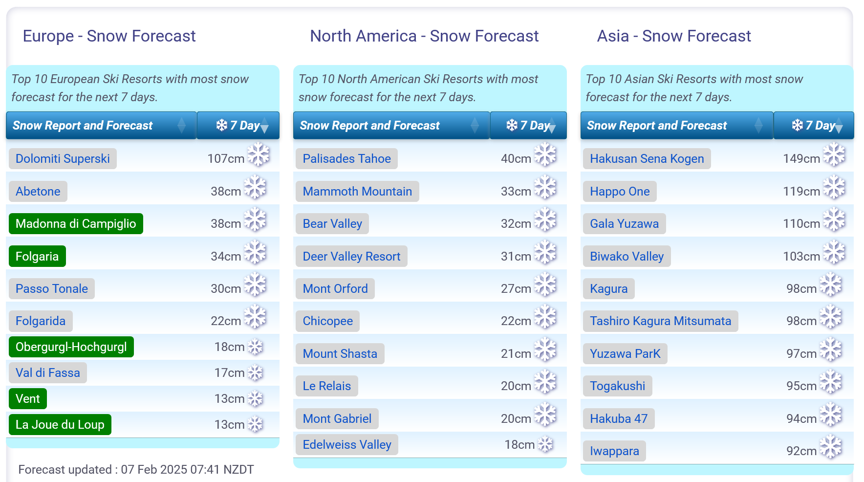
Snow forecasts worldwide.
World Overview Sunshine has dominated the weather in the Alps after last week's huge snowfalls. Avalanche danger levels have dropped slightly and those on the slopes this week have seen excellent conditions. Most centres are fully open and posting their deepest bases of the season so far. The Pyrenees, which didn't get their forecast snow at the start of last week have instead seen some light to moderate falls over the past seven days, refreshing cover. Elsewhere everything is open in the Dolomites with similar sunny weather to the Alps after last week's snowfall. Bulgaria has been dry for weeks now but temperatures have dropped again after it got rather warm last week. Across in North America a massive storm hitting the West Coast unfortunately delivered a lot of rain and violent gales rather than the metres of snowfall forecast, but there was a few feet and its still coming. There was more snow in the northern Rockies region in Idaho and Wyoming, whilst Canada remained very cold. Japan is the place that's seem the most snowfall, taking some centres past a 5m snow depth. Europe Austria It's been a great week for most Austrian ski areas and those lucky enough to be on their slopes. After last week's 30-60cm accumulations across the country, skies cleared at the weekend and it has been pretty much non-stop sunshine since. Snow depths, although not huge, are the best they've been all season and most of the country's ski areas are now 95%, or more, open. That includes one of the largest, Saalbach Hinterglemm, where the 2025 FIS Alpine Skiing World Championships, the biggest event in ski racing besides the Winter Olympics, are just getting underway. It's a similar story at The Skiwelt, Arlberg and indeed most other Austrian resorts. France Great conditions in the French Alps too after the huge snowfalls last week. Although base depths have dropped a little after last week's huge gains, three of the country's ski areas - Avoriaz, Flaine and Chamonix - are the only ones in Europe and among five outside Japan that have reached a 3m (10 feet) plus base on their upper slopes this season. Being home to most of the world's largest ski areas, including Paradiski, the 3 Valleys and The Portes du Soleil, each of which is close to 100% open, it is no surprise that the biggest areas currently available to ski are all in France too. French Alps - N90 Road Update The only problem has been getting to some of them, not from snow on the roads but giant boulders from a widely publicised landslip that caused travel chaos to and from the Tarentaise Valley last weekend. Latest news, as of this evening (Thursday), is that the authorities hope to have both lanes open in both directions following a 2 hour total closure scheduled for tomorrow afternoon (2pm to 4pm) to re-route the temporary lanes. This is subject to change, but that's the plan! The weather is turning cloudier with snowfall expected for Sunday, but currently forecast to be light. Italy Italy is also back to sunny weather following last week's snowfall. Here too bases have settled back down slightly, especially on lower slopes more impacted by plus-temperatures in the valleys in the afternoons – but overall the amount of terrain open has actually increased slightly, with most Italian areas at 90-100% open. Some famous names like Val Gardena have everything open, although others like Cortina d'Ampezzo still report bases of less than 25cm and have about two-thirds of runs open. The deepest snow continues to be in Trentino and further west and north. Here too more cloud and some snowfall is expected from the weekend into next week. Switzerland Swiss centres have had a week of predominantly sunny weather too, although skies are now starting to cloud over and there's some light snowfall forecast through the weekend. It has been quite warm at times, particularly at base levels and as a result depth stats have dropped back, particularly on lower slopes, after last week's big jumps with the heavy snowfalls. On the upside avalanche danger is widely down from considerable/high (Risk Levels 3 and 4) last week to 2 this week, on the scale to 5. The more stable conditions have also allowed centres to open more terrain after last week's snow with Zermatt, Verbier and the 4 Valleys and the Portes du Soleil each posting the most open. Scandinavia After last week's big snowfalls in Scandinavia, things have calmed down a little. It has kept snowing but totals have been more in the 5-10cm range rather the 20-40cm. Temperatures have remained mostly on the low side though, so snow conditions have remained good and most centres have been opening more terrain, also helped by rapidly increasing daylight hours, currently adding around half an hour of daylight a week. The biggest falls reported continue to be in the west of the region, on the Norwegian Coast, with Swedish ski areas Are and Salen reporting the largest areas of open terrain. Northerly Bjorkdalen, up in the Arctic Circle, begins its 2025 season this weekend. Pyrenees It's been one of the best weeks of the season, certainly of 2025, in the Pyrenees. The snowfall forecast last week arrived late, but there have been some good 5-15cm falls and cumulative totals of 20-40cm reported, the most for more than a month. As a result, bases have finally started increasing as has open terrain with the biggest resort in the region, Andorra's Grandvalira, hitting more than 75% open for the first time this season. Baqueira Beret over the Spanish border, known for its freeriding, warned the avalanche danger level is elevated there, alongside base depths, to level 3 on a scale to 5, also described as "considerable." Scotland After last week's increasingly positive news of ever more natural terrain opening (we peaked with about a third of the runs at Cairngorm, Glenshee and Glencoe open, the majority at the latter), warm temperatures since Sunday and rain at all levels on Monday have set things back a good deal. It's a fast-changing situation but it's now predominantly the all-weather machine-made snow slopes open, which are learning slopes at Cairngorm and The Lecht, longer runs at Glenshee and a sledging slope at Glencoe (which also has a dry slope for beginners). Temperatures are dropping again now and the process of base building has begun again. Eastern Europe It's been mostly sunny across Eastern Europe as well but temperatures have dropped in Bulgaria after base depths there took a small hit in last week's warm weather. Pretty much all slopes remain open though. There was some light snowfall midweek in Czechia and Slovakia for resorts including Jasna, but it just added an inch (3cm) or so of refresh and we're back to largely sunny conditions now. North America Canada The news is mostly positive this week from Canada. Whilst ski areas further south on the West coast reported a lot of rain, British Columbia and Albertan ski areas got snow, up to half a metre of it in the last seven days, exceeding the forecast predictions this time a week ago. Conditions also remain good on the east coast where centres have had some light snowfall. The only major issue has been cold as it got even colder, impacting ski areas in Alberta and inland BC especially, several of which were partially or fully closed by the low temperatures for several days at the start of this week. They included Nakiska, closest to Calgary and Jasper's Marmot Basin. USA The huge storms forecast to hit the West Coast and dump metres of snowfall arrived on cue but unfortunately, warm temperatures meant ski centres tended to see torrential rain and gales but not a lot of snow. Things have improved a little through the week and some centres have now posted several feet, cumulatively, since last Friday, if not the 10 feet plus that was forecast at one point. There's actually been heavier snowfall a little inland with Jackson Hole posting 80cm of snowfall in 72 hours, and Sun Valley 60cm in the same period. |
|
|
Not specific to Bardonecchia, but I'd definitely book in advance if you can. You don't want to waste potential ski-time...
Although Italy doesn't do half-term, it will be a busy week with families regardless. If you're of similar ability, then booking a private instructor for the 5 of you might work - and give you more flexibility than a ski school. Otherwise you'll need to find various group lessons (with space); which might need some co-ordination. |
|